There are no longer horses at our place here in Scottsville, a farm we’ve come to call “Horseshoe Hill.” Our barn did use to be home to several, though. In ode to them, our town’s location at the horseshoe bend of the James River, and the good luck we had finding such a home in the Virginia piedmont, we named it that.
Place names for Virginia homes
As far as we know, the hill on which our barn house is built had no recent name before we got here.
The Monacans once called the floodplains nearby their home. More recently, places near us have been named things such as “Payne’s Landing,” “Dobby” and “Adams” creeks, and “Beals’ Lane.” I am guessing that the Beal homestead was what the lane led to. Nowadays, though, there are approximately 40 or so smallish houses on the lane. Most are close to the road, with no mailboxes whatsoever reading “Beal.” Ah…what is in a name, or not.
Establishing boundaries
It was a while after we got started on our house that we found all the corners of the property we live on.
A friend came out with his new GPS tool he’d received for Christmas, and we were all surprised at the actual expanse of the woods. We’d thought our new property was much smaller, with creeks as the natural boundaries.
However, the property actually extended in one corner past it, and uphill to an area I have not made it back to since. The most exciting discovery was that we had an extensive trail, presumably from the former owner’s horseback riding days.
Until we finished our house, the construction and maintenance of a trail system for our own use had to wait. At some point, we realized we’d never be entirely “done” with our house, our farm, anything, really. So, in 2004-5 the earnest demarcation of the land for the trail began.
Assessing territory
That sounds more hardcore than it actually was…Michael and Jasmine took a couple of rakes out there and at winter’s end, raked all the leaves off the trail that was already there.
There are two places to access the 0.9 mile loop from our backyard; at the back east corner of our fence, and at the trailhead, behind the run-in shed/chicken coop. (Now a small barn, sans chickens, Ed.) We usually enter the trail at the east end of the fence, marked by a Red Cedar that was pretty small when we first moved here but has now grown to be a formidable tree.
Outside the house
Just off the beginning of the trail is an old outhouse we once thought held promise as a bathroom alternative until we realized it had been filled with concrete. This rendered it unusable without a retrofit. Plus the wasps had decided it made a fine home.
It is “cute”, with an outdoor latch (?) and a roof made with an old Appomattox State Forest sign. I still think it could be resurrected for its original purpose by merely substituting a green 5-gallon bucket and inserting it into the formerly deep and purposeful hole.
House of Blues(birds)
Adjacent to the outhouse is a bluebird house given us by Cole and Erin Marley as a housewarming gift our first year here. Several generations have since called this box home. Many feathered families made use of the shady but well-appointed facilities.
We’ve since moved this box to the front gate, about ten feet from our front porch because we’d heard bluebirds like people. It must be true; they raised three separate generations there their first year, in 2011.
Laid to rest
A bit more down the hill lies a small section reserved for burying well-loved homestead members; former pet rabbits, laying hens, and rowdy roosters that met their demise through various causes. (Sometimes old age and other times through violence).
This place was easily recognized by a rotting log a few years ago…the passing of time has now rendered it into a barely noticeable mound of soil. You would miss it if you did’t know what you are looking for. This still blows my mind.
Further on, there are occasional stacks of firewood where a dead tree here or there was cleared or dropped for that purpose. The wood dries and seasons, waiting for the day strong arms (or a riding mower-propelled wagon) will hoist it uphill. There the former skyscrapers of our woods will heat our home, for free with the energy it takes to carry the wood uphill and stack it.
Treehouse
A small path meanders from the main one: In just a few feet, a new treehouse in all its cedar-sided and blue-trimmed glory, is revealed. There’s railing left to complete, possibly with rustic cedar posts. It is a nice semi-hidden spot not too far the outhouse, the Barnhouse, and the birdhouse, whenever our kids might decide to sleep out there. (2012: Which they’ve done exactly once, in 2008, Ed.)
The Spring Tree
If you skip the detour to the treehouse and continue on, there is an old, less-used trail straight down to a creek’s head. We call it “the Spring tree.” The Spring tree is a beech that is at least thirty years old or possibly 100+ years old.
This tree is where we first found Michael’s initials etched previous to our moving here. Barely readable now, they are the same initials that convinced us to choose this place we now call home. Horseshoe Hill.
We found those in 2001, along with the name “Mike C,” which is also no longer identifiable. It was there long enough to serve its purpose. I think the purpose was to give us a sure “sign” that we should rest our heads here, at least for a while.
From this installed and oddly-bent Beech tree emerges the beginning of one of our creeks that branch into Adam’s Creek. This is the body of water that runs through our property and marks one of its borders. Further beyond that corner is where this branch enters.
Fallen Giant
As you follow the main path down the hill, a large oak has fallen. It created a small cave under its roots. The oak was blown down in a tornado-like storm in 2003, but was (mercifully) the only victim on our property as far as we’ve found. Luckily, it fell far from our house. Part of it will become this year’s firewood, almost five years later.
Continuing on, there are a few more piles of seasoning, and stacked wood. Barring any unusually cold winter (last year’s was unusually warm), we will already have the firewood we need. It just needs to be (womp womp) carted uphill.
Freeing the woods of wire
A few trees bear more recent scars of barbed wire. This awful stuff had infested large bits of the woods until just a few years ago. That is when our awesome friends from the Scottsville Barter network Giovanni and David came and removed what no longer kept anything out or in.
This stuff posed hazards to all hikers, trespassing or not. According to Giovanni, it also contributed to a concentration-camp vibe. It was definitely a relief to see it gone. Until we met Giovanni, we never knew someone could remove and wind that wire so rapidly. He would be a world-record holder if contests were held for such things!
Bridging the gaps
Finally, the path is breached by a small creek, over which Michael has built a small wooden bridge.
Crossing the creek further along the path also requires traversing a tree that has fallen over it with a flat-chiseled top, a few rocks, and another bridge. This particular area is spectacular when all of the mountain laurels there are in bloom. Every third year or so, they really put on a show.
In the summer, the sun glistens on the water here and is a welcome and beautiful sight.
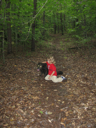
A girl and her dog
Ajah currently uses the path more than anyone. She loves walking our dog Clover one or two times a day. Often, she remarks on the changes she observes, like a leaning tree that finally fell in a most unusual way, creating a square “frame” shape. Or she will note the fluctuating height of the water, depending upon the season and precipitation frequency.
Zen Rock
One of the best spots in the woods is surely “Zen Rock.”
It is a large, jagged piece of slate? Or maybe granite? It juts out over the creek and allows the perfect space for contemplation on ripples in the water, or meditation in general.
There’s never enough time to be there long; it marks one of the corners of the property, and from there, the path takes a sharp turn uphill.
Trespasses
On these creekside trail areas, we’ve had to contend with trespassers in recent years.
A hiker that leaves not a trace but an occasional footprint is not a problem. Tire marks and broken small trees that are evidence of privileged ATV drivers are. Those types of thinggs are not appreciated in the least.
They’ve left deep ruts on the property, mess up our path, create unnatural pools of water that breed mosquitoes, and (worst of all), they create sedimentation and uglify the creek. Bad, bad.
Giving notice
Eventually, we had to acknowledge that even the rocks and huge brush piles we piled in the middle of our paths would not deter these rude intruders. Sadly, we had to erect “No Trespassing” signs as well as yellow caution tape usually associated with crime scenes.
It is ugly, and I resent that we had to do it because of someone else’s insensitive and lawless behavior. However, the presence of the bright yellow tape now protects us legally if one of these ATV drivers, adult or juvenile were to get hurt as they drove uninvited through our woods.
Unfortunate laws
It is really unfortunate that landowners are driven to this point. To protect themselves, they must put up eyesores of neon-colored signs. This ruins the scenery for hikers and drivers alike, and mars the beauty of the natural landscape.
It’s done to stave off any possible misunderstanding of who is welcome. However, shouldn’t people assume they are unwelcome to trespass unless a trail is marked public? Or they have express permission from the landowner?
It would be nice to not have to spend the money and be able to leave the ugly signs in the hardware store, and out of the woods. Trespassers should be aware that, in general, NOBODY wants an ATV driving through their woods.
If you have money for an expensive vehicle for “all terrains,” please make sure you have the money to provide your own terrain for them. Any resultant hospitable bills from their use probably aren’t worth the “recreation”. Every year, we hear of deaths of some kids from these deceptively “fun” mobiles.
Alternative “anti-trespassing” approaches
We’ve had to go through the process of repairing our trails several times. We add to brush piles and re-marking the borders with this ghastly yellow tape. It the one thing I dislike about stewarding a piece of land: marking every corner to let people know there is no trespassing allowed.
Lest someone hurt themselves, the practice is one of “better safe than sorry”. It’s really too bad that even this far from a public road, I’m still not safe from getting run over by a motorized vehicle.
The Ridge path
Leaving this area of extreme beauty (and sometimes unwanted recreation), we head up the hill to the ridge. This is where an abandoned and disintegrating bluebird house used to sit on a stump but is now decaying along with it.
There is a quickly-growing Maple-leaf Viburnum beginning to shade this area.
I suspect that his part of the path, which runs along the other ridge of our property and completes the horseshoe-shaped hill, is a remnant of the bridle-path trails of the former equestrian owner of the farm.
Signs of the recent past
This trail in the Virginia piedmont heads steadily and slightly up (or down, depending upon which way you are coming from). It leads directly to our next-door neighbor’s house. That is, if we don’t make a quick right at the three stately and aligned pine trees about a hundred feet from there. Their appearance marks the next (and final part) of our trail from this direction.
Occasionally, this is where we’ll run into our neighbor Frank. He might be walking his funny little Pug dogs Jethro and Ellie May, their names inspired by the show “Green Acres.” Our dogs Clover and Buddy do not get along well with them. So we just nod and walk quickly away from each other in our separate ways.
This part of the trail was the most treacherous before the barbed-wire removal project. We had to either jump or brave the rusted, threatening strands. The m.o. was to shimmy around or underneath them.
Neither were ever welcome prospects at the end of a nice hike. In fact, these were deterrents for a long time to walking in the woods at all.
This is also the steepest part of our land, where the trail had to be etched into the hill’s side a bit. When there is Autumn rain, the slippery fallen leaves make it almost unnavigable.
The stretch toward home
It is along this North-facing stretch that we can look down at the Spring tree branch of Adam’s creek and see a maple here and there that we had tapped for syrup.
We also planted ginseng underneath those trees. Both projects to date have not resulted in anything other than an increased awareness of how maple syrup and ginseng harvests are produced. We no longer balk at paying higher prices now that we are aware of the tasks’ difficulties!
Zone 5 (for the wildlife only)
We still have the taps and buckets and the knowledge, so we haven’t ruled out trying again one day. This slippery slope of dreams leadsus down a path infested with privet. The gully just beyond presents an incredible habitat for butterflies and native plants. Both thrive here, where humans rarely tread.
Occasionally, I entertain the idea of introducing goats here (a la “Goatbusters”) to clear the privet away. However, I do not care for most Capricorns besides my husband, that’s probably not a good enough reason to make a production of it.
Those thoughts, then, are short-lived. I prefer sheep, but I do not think they prefer privet. So, this overgrown portion of the property remains until we come up with a better plan. After being here for so long, I am beginning to think we won’t. At least soil will is held in place by privet, and it deters ATV drive-bys. That is a good thing.
(Almost) Full circle
Beyond this, we arrive at the treehouse again. This time to its backside. The structure itself rests in one of the Maple trees we tried to tap a few years back. Our efforts yielded no noticeable sap.
The year we tried was apparently one of the worst seasons in recent history for tapping. There’s always NEXT Spring, I guess.
More Zen
Going past the treehouse on the left, there’s a small (now hidden) path to Michael’s Zen garden.
It is a 3 x 6′ sand tray with a few large rocks, a bamboo rake. Since it is off the beaten path, I am not sure how much Zen happens here. Probably not much, which, if you think about it is actually very Zen-like.
Out of the woods
Back on the main trail, veering to the left, the path becomes very steep again. The woods seem quite dark here, even on the sunniest of days. It’s almost entirely pine and cedar here, with very little understory. Only needle litter and it has the feel of an overgrown Christmas tree farm.
Stark contrasts
The path continues upward through it all, and lands you smack behind the chicken coop. (Not the best planning, but there it is). The day is exceptionally hot, and the chicken house is full. This can be unpleasant, but if you remind yourself how good the morning’s omelet was, you get over it pretty easily.
Keep heading up the trail. The house is now clearly visible. If it is winter, you’ll head to a warm hearth inside. If its summer, a cool glass of water will be yours for the welcome.
Future plans and past dreams
If Michael and I are with you, we’ll probably mention at some point along the hikes (or right after it ends) that we’d love to make a “Medicine trail.”
This is an idea we’ve had since visting one in Belize. A “Medicine Trail” contains many fully-labeled plants for medicine along a trail. It’s a rather simple idea. Our few attempts at establishing this kind of trek have become invisible. Labels disappeared and based on our lack of enthusiasm for other signs of humans (such as the yellow tape “NO TRESPASSING” tape downhill) it’s all just as well.
(This was written in Fall 2007, I no longer live here. But I do have fond memories of this homemade trail and hope it still sees frequent use!-M.M.)